
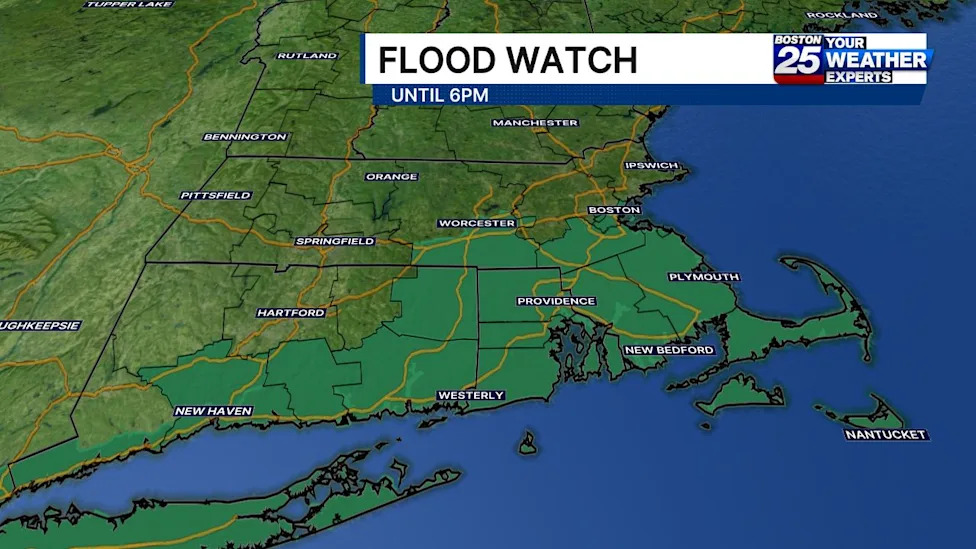
A potent cluster of heavy precipitation and atmospheric instability has triggered a comprehensive severe weather alert across southern New England, placing a vast portion of Massachusetts under an active flood watch through Sunday evening. Regional meteorologists emphasize that the incoming weather pattern brings a substantial threat of intense downpours, localized flash flooding, and potential infrastructure disruptions across numerous coastal communities, suburban districts, and densely populated municipal centers.
The flood watch advisory formally encompasses eight individual counties across eastern, southeastern, and central Massachusetts: Bristol, Plymouth, Barnstable, Dukes, Nantucket, Worcester, Norfolk, and Suffolk. Municipalities within these designated jurisdictions have been advised to prepare for rapid water accumulation on surface streets, rising levels in vulnerable waterways, and localized runoff hazards affecting both low-lying residential properties and commercial zones.
According to official weather bulletins, the advisory is slated to remain in effect until 6:00 p.m. on Sunday. The primary axis of precipitation is oriented along and south of the Massachusetts Turnpike, establishing this key transportation and population corridor as the main geographical divider for the most acute atmospheric moisture and potential flash flooding risks throughout the day.
Detailing the progression and movement of the storm system, Boston 25 meteorologist A.J. Mastrangelo reported that a concentrated cluster of heavy rain was projected to slide steadily into southeastern Massachusetts beginning in the late morning hours. Broadcast forecasters underscored that communities located along and south of the Mass Pike would face persistent monitoring requirements as the system advanced across the coastline.
The broader weather setup is characterized by extensive bands of showers accompanied by embedded thunderstorms. These convective cells are capable of generating intense, highly localized downpours that can deposit massive quantities of water within short timeframes, significantly outpacing the natural absorption capacity of the surrounding ground and regional drainage networks.
From a general accumulation standpoint, widespread rainfall totals across the affected southern New England region are anticipated to range between 0.50 inches and 2.0 inches. However, forecasters have repeatedly cautioned that these general baseline figures do not fully reflect the localized severity that could manifest under the most intense storm cells.
The chief hazard of the day stems from narrow, localized bands of torrential downpours that could generate between 2 and 4 inches of rainfall within a narrow window of just three hours. Because these extreme rainfall rates occur over such a compressed duration, even well-established storm management systems can experience severe strain.
The National Weather Service issued a cautionary statement regarding the uncertainty surrounding the precise geographic track of these narrow downpour corridors. Forecasters specifically warned that while it remains challenging to pinpoint exactly where the heaviest bands will materialize, localized flash flooding is highly possible, particularly if these high-volume cells stall or develop directly over vulnerable urban centers.
Urban environments throughout Suffolk, Norfolk, and Bristol counties present elevated concerns due to the high density of impervious surfaces, including paved highways, expansive parking structures, and commercial developments. When excessive rainfall rates strike these metropolitan areas, stormwater systems can quickly become overwhelmed, leading to rapid water accumulation on major transit arteries and subterranean structures.
The widespread nature of the flood watch reflects broader atmospheric conditions sweeping across the southern New England landscape. As convective storm bands move across the region, emergency response teams and regional transportation authorities are keeping a close eye on hazardous road conditions and localized ponding that could affect weekend travel.
To assist the public in managing weather-related disruptions, state emergency officials have highlighted several critical informational tools. The Massachusetts Emergency Management Agency encourages residents to utilize its real-time power outage viewer to monitor regional electrical grid stability, tracking localized outages and reviewing estimated restoration times provided directly by utility companies.
In addition to electrical tracking capabilities, state agencies recommend that residents and municipal officials utilize MEMA’s live weather radar interface and online forecasting tools. These digital tracking instruments allow the public to monitor approaching rain bands in real time and evaluate changing weather developments within their specific towns and neighborhoods.
Community members seeking additional guidance or assistance are directed to established support networks, including the Mass211 informational directory. Broader regional assistance and safety protocols are also supported by resources available through the Federal Emergency Management Agency, which coordinates with local and state officials during significant weather emergencies.
Ongoing meteorological evaluation is being coordinated closely with National Weather Service regional forecast offices located in Boston and Albany, New York. These scientific agencies continue to assess real-time radar imagery, ground-level gauge measurements, and atmospheric modeling to update alerts as localized rain bands evolve through the afternoon.
With the flood watch remaining active until late Sunday afternoon, emergency managers urge residents throughout central, eastern, and southeastern Massachusetts to remain alert to changing sky conditions. Drivers are strongly advised to avoid navigating through flooded roadways and to rely on updated meteorological warnings until the heavy precipitation system clears the area.


(0)