
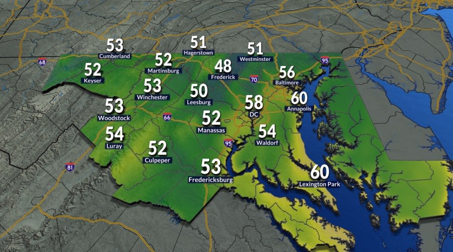
Residents across the Washington, D.C., metropolitan region experienced a distinct and refreshing change in the atmosphere on Tuesday morning, as an influx of cooler air delivered the first genuine preview of the approaching autumn season. Commuters setting out early encountered morning temperatures dipping cleanly into the 50s, creating an invigorating chill that stood in sharp contrast to the persistent warmth that dominated the region throughout the preceding months.
The arrival of morning lows in the 50s represents a noteworthy meteorological milestone for the nation's capital. To locate the last time Washington recorded temperatures this cool during the early morning hours, forecasters note that one must look back more than three months to June 3. This extended stretch between crisp mornings highlights the prolonged grip of summer conditions that the region has navigated across the summer months.
The sudden dip in early morning numbers required many local residents to reach for extra layers and light jackets before stepping outside for their Tuesday morning commutes. However, the chilly start will not linger for the entire day, as the brisk conditions are scheduled to give way rapidly once daytime heating gets fully underway across Maryland, Virginia, and the District.
By Tuesday afternoon, the area is slated to enjoy ideal late-summer and early-fall weather. Temperatures are forecast to rebound nicely, climbing into the upper 70s and lower 80s under abundant sunshine. The comfortable warmth will be further enhanced by noticeably low humidity levels, creating an exceptionally pleasant atmosphere for outdoor recreation and afternoon travel.
The refreshing weather pattern is expected to extend into the middle of the week, offering another comfortable start on Wednesday morning. While Wednesday will feature another crisp dawn, temperatures are not projected to drop quite as low as Tuesday's morning marks, providing a slightly milder waking environment for early risers across the area.
As Wednesday progresses, the afternoon will turn slightly warmer than the previous day. Thermometers are projected to reach the lower to mid-80s under predominantly sunny skies. Despite the slight uptick in daytime temperatures, the overall environment will remain largely comfortable, preserving a favorable setup for outdoor activities across the greater metropolitan corridor.
Meteorologists emphasize that area residents should take full advantage of the favorable conditions present on both Tuesday and Wednesday. The brief spell of dry, comfortable air is slated to be temporary, with a more humid and unsettled airmass scheduled to encroach on the Mid-Atlantic region toward the latter half of the workweek.
By Thursday, the atmospheric flow will shift, ushering in a noticeable return of moisture and warmth. Partly sunny skies will accompany afternoon high temperatures climbing into the upper 80s. Alongside the higher temperatures, climbing dew points and humidity will make conditions feel considerably stickier and more typical of mid-summer than early autumn.
The shift toward more active weather will culminate on Friday as a defined cold front presses into the region from the northwest. The arrival of this boundary will destabilize the atmosphere, setting the stage for increased cloudiness and bringing wet weather back into the local forecast after several days of dry conditions.
Friday's forecast calls for high temperatures reaching into the upper 80s paired with elevated humidity levels throughout the day. As the cold front nears during the afternoon and evening hours, isolated showers and thunderstorms are expected to develop across the region, potentially impacting the Friday evening commute and outdoor plans.
Following the passage of the frontal system, the weekend will bring a slight moderation in daytime high temperatures. Both Saturday and Sunday are expected to top out in the mid-80s, keeping afternoon readings warm but slightly reduced from the late-week peaks.
While the front will have cleared parts of the area, moisture will linger across the region through the remainder of the weekend. Forecasters indicate that while unsettled weather remains possible on Saturday, Sunday will carry a comparatively higher likelihood for renewed shower and thunderstorm development across the region.
Looking ahead to the start of the following workweek, the weather pattern is projected to settle into a calmer and cooler configuration. The region is expected to kick off the new week with daytime highs resting near 80 degrees beneath primarily cloudy skies, offering a more subdued environment compared to the stormy late-week stretch.
This transitional period comes just ahead of an official seasonal milestone on the calendar. Following this series of fluctuations between crisp mornings, summer-like heat, and scattered rainfall, astronomical autumn is scheduled to make its official arrival on Tuesday of next week, bringing a permanent close to the summer season.


(0)